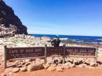
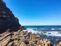
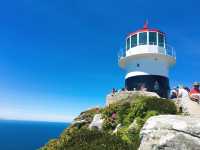
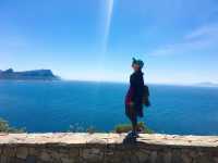
Cape of Good Hope is the name given by the King of Portugal to a Portuguese King at the southwest end of the Atlantic Ocean. It is a very famous Cape at the southwest end of Africa. It is located at 34 & #176; 21'25 "" S, 18 & #176; 29'51 "" E. It is 52 kilometers north of Cape Town, Republic of South Africa. Because of many storms and rough seas, it was originally called "Storm Angle". In 1939, it became a nature reserve with a lighthouse 2 kilometers east of Cape Good Hope. The Cape of Good Hope is the eastern waterway for Western explorers. Before the opening of the Suez Canal, ships between Asia and Europe passed through the Cape of Good Hope. Extra large tankers cannot enter the Suez Canal and still need to take this route for navigation. The Cape of Good Hope is often mistaken for the southernmost tip of the African continent, but it is about 150 km east-southeast of the Cape of Egales across the Bay of Fowles. The Cape of Good Hope is located at the confluence of the warm Mozambique Egal Current from the Indian Ocean and the cold Benguela Current from Antarctic waters. Strong westerly torrents have caused great waves all the year round. In addition to storms, there are often "killing waves" here. The front of the wave is like a cliff, and the back is like a gentle hillside. The wave height is usually 15-20 meters. It occurs frequently in winter, and sometimes it is accompanied by rotating waves caused by polar winds. When the two waves are combined, the sea condition becomes worse. There is also a strong coastal current. When the waves meet the current, the whole sea rolls over like a pot and sails here. Ships often suffer, making it the most dangerous part of the world's navigation.
好望角評價
4.7 /5456條評價


1 / 9


5/5
好望角
發佈日期:2016年10月9日


4人讚好
讚
 5/5完美原文
我真的很喜歡這個景點!它有驚人的景色,不需要高水平的體力來承擔。公園本身內部,有很多你可以做,但你需要一輛車才能充分利用
發佈日期:2024年1月28日0 5/5完美原文
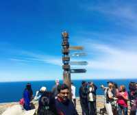
非洲大陸最西南的點。這裏的景色很壯觀
發佈日期:2023年10月1日0 5/5完美
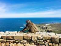
5/5完美好望角位於一個國家保護區內,進入一道帶有鐵絲網圍牆大門的進口,裏面就是國家負責的區域,這裏一切都是屬於國家所有,包括鴕鳥、羚羊、大象、狒狒……一路上,我們居然看見了鴕鳥在原野上覓食。
發佈日期:2023年6月8日0 5/5完美
5/5完美【景色】美麗【趣味】很不錯【性價比】高
發佈日期:2023年8月12日0 5/5完美原文
這是呼吸!!絕對喜歡每一刻。會在您的旅行中推薦這個。它可以作爲半天的旅行完成。
發佈日期:2023年1月26日0- 1
- 2
- 3
- 4
- 91
好望角常見問題
更多相關問題
Raelynn_Snider: 我推薦好望角,好望角自然保護區,Cape Point Nature Reserve,Flying Dutchman Funicular,Old Cape Point Lighthouse
1個答案
TripTraveler: 好望角附近還有這些熱門的景點可以一起遊覽哦:開普敦之心博物館,Twelve Apostles,南非企鵝生態保護區,Seaforth Beach,Warrior Toy Museum
1個答案
熱門目的地
熱門目的地的推薦景點
深圳的附近景點 | 東京的附近景點 | 台北的附近景點 | 香港的附近景點 | 大阪的附近景點 | 曼谷的附近景點 | 澳門的附近景點 | 首爾的附近景點 | 廣州的附近景點 | 珠海的附近景點 | 上海的附近景點 | 倫敦的附近景點 | 福岡的附近景點 | 吉隆坡的附近景點 | 高雄的附近景點 | 新加坡的附近景點 | 北京的附近景點 | 沖繩的附近景點 | 巴黎的附近景點 | 名古屋的附近景點 | 札幌的附近景點 | 台中的附近景點 | 成都的附近景點 | 布吉的附近景點 | 京都的附近景點 | 悉尼的附近景點 | 馬尼拉的附近景點 | 溫哥華的附近景點 | 釜山的附近景點 | 佛山的附近景點
熱門景點
螢火蟲水洞 | M+ | 九寨溝風景區 | 雙威主題樂園 | 恐龍園侏羅紀水世界 | 長隆宇宙飛船 | 北京環球度假區 | 珠海海泉灣海洋溫泉 | 亞洲國際博覽館 | 秦始皇帝陵博物院(兵馬俑) | 白水寨風景名勝區 | 大鵬灣 | 望仙谷 | MELAND(深圳龍崗萬達廣場店) | 西禾裏·影院足道·SPA館(萬象天地店) | Djemari Reflexology | Vista Yacht Cruises | Bookstore waves and words | Gateway Gardens | Leister Park | Kloster St. Lambrecht | Retro Bowl | 金東尼人妖秀 | 長江索道 | 四方水上市場 | 馬來西亞樂高樂園 | 盧浮宮 | 夜間野生動物園 | 珠海橫琴獅門娛樂天地 | 新濠影滙滿紛樂園
熱門遊記
熱門排行榜
獻縣附近的熱門親子景點 | 首爾24大高級餐廳 | Curug Sangereng附近的熱門奢華酒店 | 利辛附近的熱門親子景點 | 崑山附近的熱門親子景點 | 金邊9大Club | 巴厘省的熱門奢華酒店 | 鶴壁附近的熱門親子景點 | 富士河口湖町8大當地風味餐廳 | 漵浦附近的熱門親子景點 | 馬尼拉5大酒吧 | 南靖的熱門豪華酒店 | 科倫坡11大酒吧 | 聖卡洛斯縣附近的熱門奢華酒店 | 土默特右旗附近的熱門親子景點 | 馬爾多納多省的熱門奢華酒店 | 澳門20大高級餐廳 | 梭桃邑縣附近的熱門奢華酒店 | 首爾11大奢華酒店 | 喀布爾省的熱門豪華酒店 | 曼谷10大夜間景點 | 首爾11大夜間景點 | 東京19大夜間景點 | 南京5大夜間景點 | 西安9大夜間景點 | 三亞14大夜間景點 | 長沙5大夜間景點 | 重慶12大夜間景點 | 成都12大夜間景點 | 廣州6大夜間景點