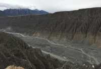
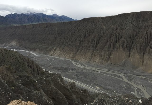
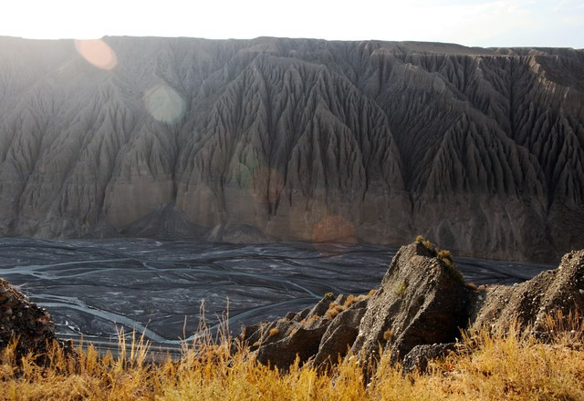
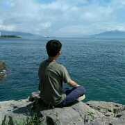
奎屯河大峽谷位於天山北麓,地處奎屯市西南方向近20公里處,沿217國道可至。其地層完全是礫石和沙土組成,遠古時代應是海底,經過地質活動隆起為陸地。 天山雨雪及河水經年不息地沖刷,在這塊平整的土地上沖刷出了一個百米多深的大峽谷。奎屯河出山後切割傾斜平原形成巨大的峽谷,近南北走向,長約20公里,谷底寬100~400米,谷肩寬800~1000米,從谷底到谷肩高可達200米。谷壁近直立,沿谷到處是斷崖,谷壁上的沖溝將谷壁雕鑿成石林狀,奇特險峻。谷底平展開闊,河灘上礫石遍地,流水時合時聚,谷底東側的水渠順谷底延伸,構成一幅美麗畫圖。
奎屯河大峽谷評價
4.6 /572條評價


1 / 3


5/5
奎屯河大峽谷
發佈日期:2019年5月2日


12人讚好
讚
 5/5完美
5/5完美獨庫公路上的重要一環,風景不錯,但是對於我來說是第二次來了,感覺還是沒啥意思,獨庫公路我只建議走一次就好,第二次的話就無聊了。
發佈日期:2021年8月20日0 5/5完美
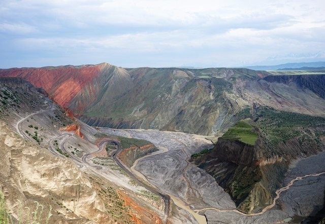
5/5完美千萬不要認為奎屯河大峽谷就是因為奎屯河的衝擊而形成的,整個大峽谷形成的原因,完全是因為地窖的運動。也千萬不要糾結自己到底是去奎屯河大峽谷,還是去安集海大峽谷,或者是紅山大峽谷。其實三個峽谷的地質特徵都是差不多的,只不過是處在不同的地理位置段而已,如果讓我來推薦的話,我還是首推去安集海大峽谷。當然不管你去哪個峽谷,最重要的就是遇到一個好的天氣,只有好的天氣,你才能拍出大自然在這個峽谷上所雕刻的各種美,哪怕是一道河水留下的痕迹。
發佈日期:2020年3月15日3 5/5完美
5/5完美位於奎屯市南面,距市區18公里,因千萬年來天山雪水自然沖刷形成,南北走向,長約20公里,谷底寬100~400米,谷肩寬800~1000米,從谷底到谷肩高可達200米。現場看到時真的很震撼,儘管早就在別人的遊記中看到過。
發佈日期:2019年12月4日3 5/5完美原文
Kuitun River Grand Canyon, located 20 kilometers southwest of Kuitun City, Ili Kazakh Autonomous Prefecture, is not open to Xinjiang Tourism Bureau because of its dangerous terrain. The Grand Canyon runs quietly in the upper reaches of Kuitun River, where ice and snow melt in Tianshan Mountains. It is like a carved Canyon ravine, with nine meanders, rocky cliffs and spectacular scenery. The bottom of the canyon is composed of three streams: the confluence of the three rivers, forming a unique landscape. Cliffs have many colors, such as red, brown and black, forming a gorgeous Canyon ravine. When the sun rises in the east, the canyon is full of sunshine, which is a natural picture given to us by nature.
發佈日期:2017年4月18日84 5/5完美原文
The Kuitun Grand Canyon is in the upper reaches of the Kuitun River, where ice and snow melt in Tianshan Mountains. Because of the natural erosion of snow and water in Tianshan Mountain for tens of millions of years, it is about 20 kilometers long, 100-400 meters wide at the bottom of the valley, 800-1000 meters wide at the shoulder of the valley, and up to 200 meters high from the bottom of the valley to the shoulder of the valley. The valley wall is nearly upright, with cliffs everywhere along the valley. The gullies on the valley wall carve the valley wall into stone forest, which is strange and precipitous. The Kuitun River passes through the bottom of the valley, along with millions of years of rainwater erosion, leaving weaved gullies, rills, cutting ditches on the suspension wall of the downward cut valley where gravel accumulates. The gullies are covered with the walls of the valley channel for tens of kilometres, forming a beautiful picture. Nature's skillful manipulation of nature, the God-made ghost axe, shocked every one of us, sincerely sent out the United States of Xinjiang!
發佈日期:2018年7月7日8 5/5完美原文
The road is very steep, drive slowly, stones fall from the hillside at any time, pay attention to safety, the road is very narrow, or two lanes, but the scenery is good, it is worth driving from inside, there is snow on the roadside in July.
發佈日期:2017年7月24日13 4/5極好原文
In the upper reaches of the Kuitun River, along the edge of a coal mine, a section of Canyon ravine, like a sculpture, after hundreds of millions of years of roaring and rushing water, erosion of snow and wind, makes a breathtaking picture of natural history on both sides of the cliff, and achieves an amazing spectacle of water erosion. At present, there is no charge. The weather was not good on the day, but the scenery was still very picturesque.
發佈日期:2017年10月4日12- 1
- 2
- 3
- 4
- 15
熱門目的地的推薦景點
深圳的附近景點 | 東京的附近景點 | 台北的附近景點 | 香港的附近景點 | 大阪的附近景點 | 曼谷的附近景點 | 澳門的附近景點 | 首爾的附近景點 | 廣州的附近景點 | 珠海的附近景點 | 上海的附近景點 | 倫敦的附近景點 | 福岡的附近景點 | 吉隆坡的附近景點 | 高雄的附近景點 | 新加坡的附近景點 | 北京的附近景點 | 沖繩的附近景點 | 巴黎的附近景點 | 名古屋的附近景點 | 札幌的附近景點 | 台中的附近景點 | 成都的附近景點 | 布吉的附近景點 | 京都的附近景點 | 悉尼的附近景點 | 馬尼拉的附近景點 | 溫哥華的附近景點 | 釜山的附近景點 | 佛山的附近景點
熱門景點
夜間野生動物園 | 玉龍雪山 | 聖淘沙島 | 雲頂天城世界主題樂園 | 大阪温泉大世界 | 博多運河城 | 曼谷野生動物世界 | 香港挪亞方舟 | 澳門teamLab超自然空間 | 貓空纜車 | Pokiddo口袋屋運動夢工場 | 富士急樂園 | 上野公園 | 名木百選 大宮神社のイチョウ | Park | Urban Look | Şeyh Halef Cami | Delhi Dreams library | Arena Beach | Millwards Park | Table Land - World Record Holder Plateau | Ram Temple | Khukhundva Park | 新加坡環球影城 | 日月潭 | 富士山 | 珠海長隆海洋王國 | 永慶坊 | 哈利波特攝影棚 | 香港杜莎夫人蠟像館
熱門遊記
熱門排行榜
獻縣附近的熱門親子景點 | 首爾24大高級餐廳 | Curug Sangereng附近的熱門奢華酒店 | 利辛附近的熱門親子景點 | 崑山附近的熱門親子景點 | 金邊9大Club | 巴厘省的熱門奢華酒店 | 鶴壁附近的熱門親子景點 | 富士河口湖町8大當地風味餐廳 | 漵浦附近的熱門親子景點 | 馬尼拉5大酒吧 | 南靖的熱門豪華酒店 | 科倫坡11大酒吧 | 聖卡洛斯縣附近的熱門奢華酒店 | 土默特右旗附近的熱門親子景點 | 馬爾多納多省的熱門奢華酒店 | 澳門20大高級餐廳 | 梭桃邑縣附近的熱門奢華酒店 | 首爾11大奢華酒店 | 喀布爾省的熱門豪華酒店 | 曼谷10大夜間景點 | 首爾11大夜間景點 | 東京19大夜間景點 | 南京5大夜間景點 | 西安9大夜間景點 | 三亞14大夜間景點 | 長沙5大夜間景點 | 重慶12大夜間景點 | 成都12大夜間景點 | 廣州6大夜間景點