OverviewBookNearbyReviewsWin PrizesRecommended
Share to
Dalingshan Forest Park
大嶺山森林公園3.6
105 Reviews
Open Opens at 05:30-19:30
Recommended sightseeing time:1 day
Address:
At the end of Huanlin Road, Daling Mountain, Dongguan City, go straight west for 500 meters.Map
Phone0769-85551004
What travelers say:
Dalingshan Forest Park is located in Dongguan City, surrounded by Daling Mountain, Humen, Dalang and other towns, 530 meters above sea level, there is a pavilion on the top of the mountain, because the tea trees are all over, the famous tea fun.
More
See all 2 photos
Saved by 25
Dalingshan Forest Park Highlights: Must-See Features and Attractions
Some information may have been translated by Google Translate
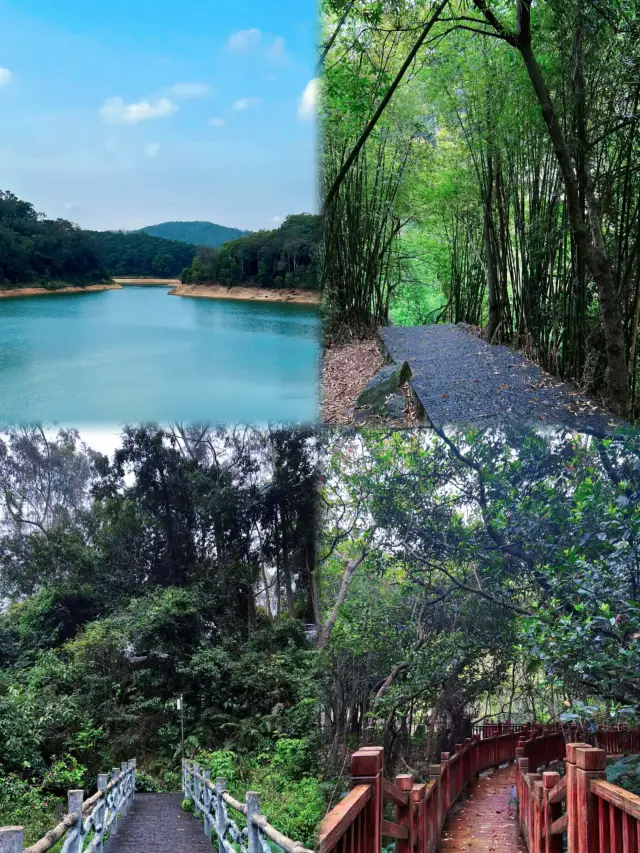
Dalingshan Forest Park is located in the southwest of Dongguan City, surrounded by green forests and mountains. There are many hiking trails to the main peak—Dalingshan—which offers a terrific view of the Pearl River and rolling hills below. A golden statue of Maitreya, or future Buddha, stands in the park, as well as a nearby temple where the faithful go to pray. The park is divided into six main areas, including Shidong Scenic Area, which features a serene, comfortable environment. Huaihu Reservoir is also a gem in the area, featuring a 7-kilometer, tree-lined trail around the lake, perfect for a leisurely bike ride.
Recommendations Near Dalingshan Forest Park
Dalingshan Forest Park Reviews: Insider Insights and Visitor Experiences
Some reviews may have been translated by Google TranslateWrite a Review
/5
Outstanding ReviewsAll (105)
Latest
Photos (50)
Positive (97)
Negative (2)
- 1
- 2
- 3
- 4
- 21
Dalingshan Forest Park Photos: Trip Moments
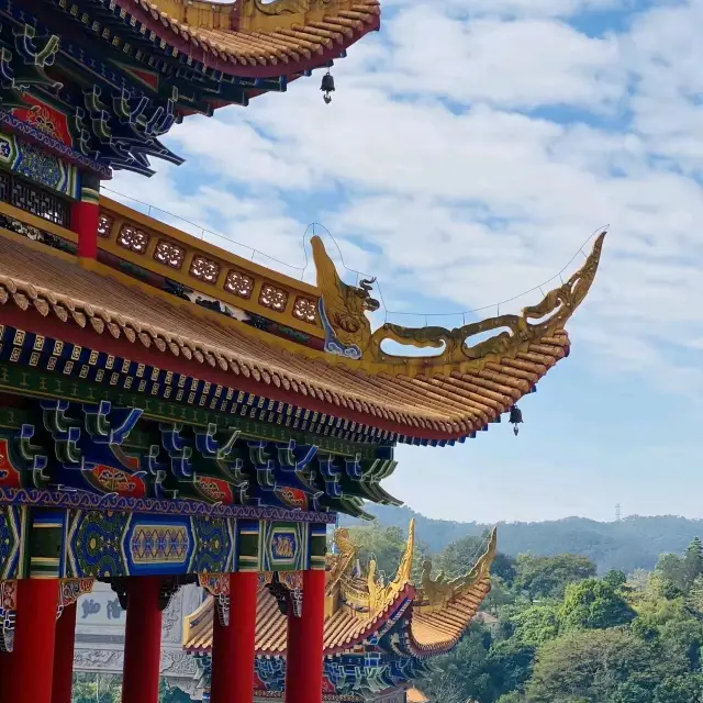
 Dalingshan, DongguanGuangdong's Most Beautiful Temple | Dalingshan Forest Park Guanyin Temple in Dongguan It is said that nowadays many young people choose to offer incense between work and self-improvement; choose Buddha between seeking others and seeking self; choose a Buddhist approach between relationships and systems; choose the compassion of Buddha between sorrow and great sorrow! Today, I recommend a great place for offering incense and praying to Buddha hidden in the deep mountains—Dalingshan Forest Park Guanyin Temple in Dongguan Not only can you kneel in the God of Wealth Hall without getting up, but there are also the Heavenly King Hall, Tai Sui Hall, Guanyin Hall, Ancestral Master Hall, and so on for you to worship at will~ (Incense is available at the entrance for 20/bundle, or you can bring your own, which has requirements, see P13) Inside the Guanyin Temple, the architecture is well-arranged, with each floor housing various halls, reflecting extremely symmetrical architectural aesthetics. The highest point of the temple is the Dharma Hall, which can be reached by elevator directly to the top, overlooking the entire Guanyin Temple, layer upon layer of Buddha's blessings, protecting all beings, and offering a magnificent and spectacular view! Temple Tour Guide: Tickets: Free Opening Hours: 6:30-19:00 (Entry to the temple will be restricted after 18:30, overnight stays are not allowed, please leave before the temple closes) About Food and Drink: The temple's vegetarian hall is open for buffet from 11:00-14:00 (20/person), and the Zen Tea House is open all day for tea tasting at your pleasure,aella_62741
 After climbing Dalingshan, I feel like I've been healed!After climbing Dalingshan, I feel like I've been healed Spring is really suitable for climbing Friends living in Dongguan and around Dongguan You can really come to Dalingshan Park in Humen to breathe fresh air on weekends The whole forest is a natural oxygen bar, the greenery is very friendly to the eyes, and the Daxi Reservoir is spectacular I feel like I can easily take big shots, and the traffic is quite convenient If you get tired, you can also take a taxi on the mountain road:🚗 Dongguan Dalingshan Forest Park:🎫Freeleonaris_6881
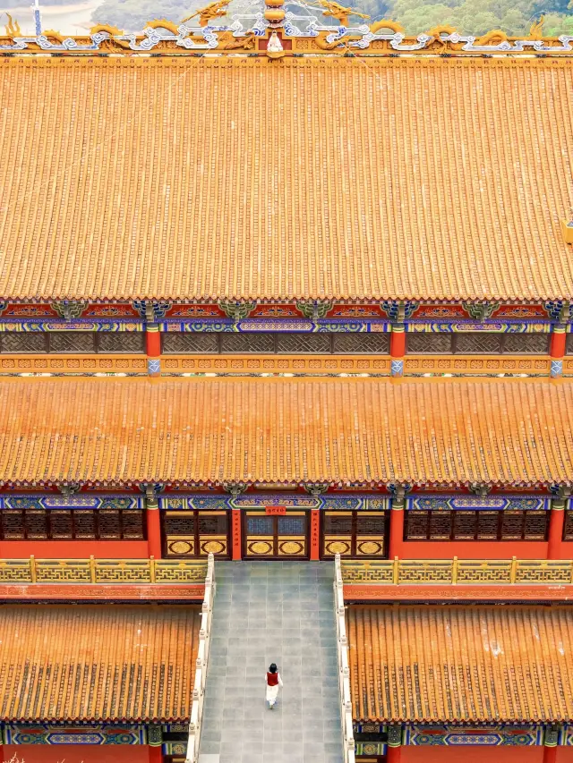 Not in Beijing!! In Dongguan!! The little Forbidden City that is asked crazyIt's hard to imagine that there is a 'Guangdong version of the Little Forbidden City' hidden in the deep mountains of Dongguan! Bring the dragon year element props to pray and visit here🐲 By the way, hike Dalingshan⛰️ Came here for its reputation, it's simply shocking, keep the one-day tour guide~ - ⛩️Dalingshan Guanyin Temple has a history of more than 300 years, with a total of 19 floors in height, you can drive directly, and there is a parking lot on the mountain. After visiting Guanyin Temple, you can reserve 3-4 hours to hike the Dalingshan small loop. 🐲What attracts us is not only the Guanyin Temple itself, but also the cultural treasures that have been precipitated for thousands of years! Walking into here, you can see flying dragons and Hanfu everywhere, deeply feeling the charm of the 'Chinese Year'! - ⚠️Here are some check-in tips: 1️⃣The high-speed rail is near Humen Station, and the taxi fare is about 35 yuan; 2️⃣Incense is 20 per bunch, 3 per incense burner, just used up; 3️⃣There are many check-in positions, detailed check-in points and Dalingshan hiking routes are in the last picture; 4️⃣It is recommended to drive by yourself, friends who don't drive remember to call a taxi in advance when going down the mountain; 5️⃣Suitable for wearing Hanfu, or bring some dragon year propsScarlettButler^86
- scenicspotguide
- trip
- temples
- nature
⛰️⛩️ Delightful DaLingShan ⛩️⛰️Such a secret little gem with so much to explore! A relatively little talked about park located between Dongguan on Shenzhen, this park is huge! There is a recently developed temple with so many beautiful little details. There are seemingly infinite paths all around the trees with some leading up to the peak. A lovely flat forest path winds its way around a 7km lake which is great for cycling. This forest is a great place to escape the city and can happily cater for families, hikers, or sole travellers! #scenicspotguide #trip #temples #nature ##chinatravelDruid1076
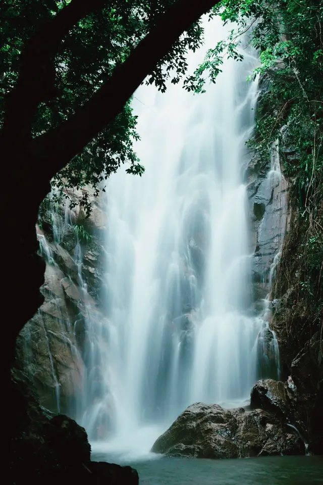 Dongguan Weekend Niche Stream Tracing and Photo Spot - DalingshanNavigation: Dalingshan Forest Park Houjie Scenic Area Parking Lot Route: If the car is parked at the Houjie parking lot, you need to walk along the road to the P3 fork. If the car can drive in, you can drive to the fork and park, then walk in (the road was blocked by fallen trees after the typhoon when we went). At the fork, take the middle path on the left with the pavilion, and after about 15 minutes, you will see a yellow P4 sign on the right. Start stream tracing at the red arrow. Along the way, you will pass through P5, P6, P7 series of bushes, and eventually reach the P8 destination. Precautions: 1. Pay attention to weather changes to avoid exploring waterfalls on rainy days as the stones next to them are slippery; safety first. 2. You will pass through a lot of bushes and stones along the way, it is recommended to wear long sleeves, long pants, waterproof jackets, and non-slip shoes. 3. Bring an umbrella, mineral water, snacks, garbage bags, photography equipment, etc. 4. Take your trash with you when you leave, so that others can also see the beauty. Difficulty: Overall, the difficulty is not high. Including photo-taking and retrieving the car, the whole journey takes about 2-3 hours, and the stream tracing route takes about 1 hour back and forth. The signal in the mountains is poor, so it is recommended that groups of three or more people participate for mutual assistance. Outdoor experts may ignore this advice.MichaelMcNeil89
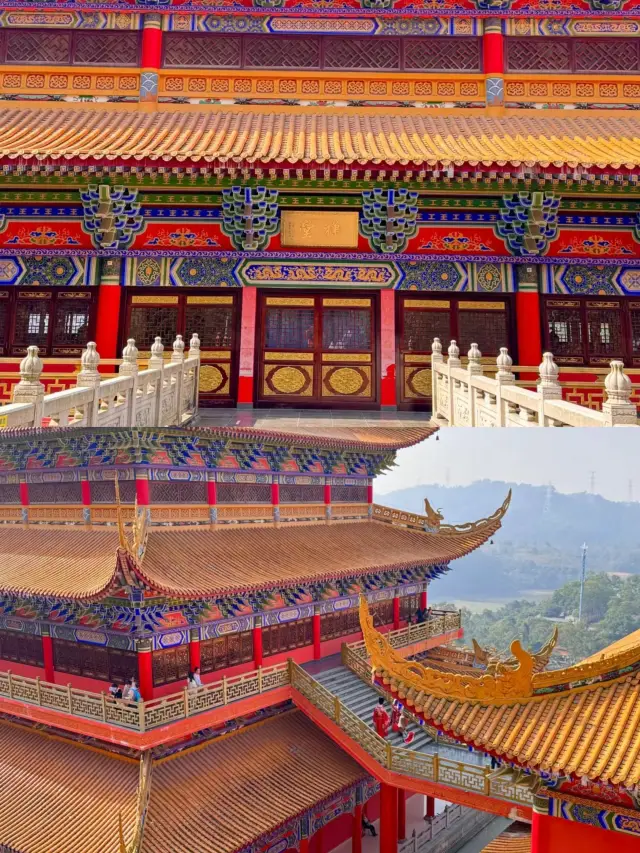 Dalingshan Guanyin Temple | 0 yuan ticket to check in the "Little Forbidden City" of Guangdong| 0 yuan ticket to check in the "Little Forbidden City" of Guangdong.🚩Today, I will recommend a small and popular secret place only 1 hour's drive from Guangzhou - Dalingshan Guanyin Temple. This temple was built in the Ming Dynasty and has a history of more than 300 years. After continuous expansion, the current Guanyin Temple is nearly 19 stories high, with a majestic momentum! It is known as the "Forbidden City of Guangdong". The red walls and yellow tiles in the temple 🏛, every shot is a big scene. 🎉Not only is it a Buddhist holy land, but it is also a very suitable place for couples to take wedding photos. You can see couples leaving beautiful memories here, making people feel the romantic atmosphere. The most important thing is that there is no need for tickets here, and no parking fees! If you have no plans for the weekend, you might as well come here for a walk, I believe you will definitely gain a lot of happiness. 📌Play small tips: - After entering, walk up from the left, and then exit from the right (clockwise). - Incense can be asked at the entrance, 20r/bunch. - There is a vegetarian restaurant in the temple, which provides buffet from 11:00-14:00, 20r/person. - There is an elevator on the left side of the temple to each floor, no need to climb stairs. - It is recommended to go on weekdays, less people and good photos; try to go in the morning on holidays. - The main photo location is on the left side of the scenic area, with a good angle. 🚗Nearby attractions: Dalingshan Forest Park has a reservoir for play (free). 📍Location: Guanyin Temple in Dalingshan Forest Park, Dongguan 🚝Transportation: - Guangzhou South-Humen High-speed Railway Station (17 minutes in total). - After exiting the station, take the No. 15 bus or taxi to Dalingshan Forest Park.GREY RODRIQUEZ1
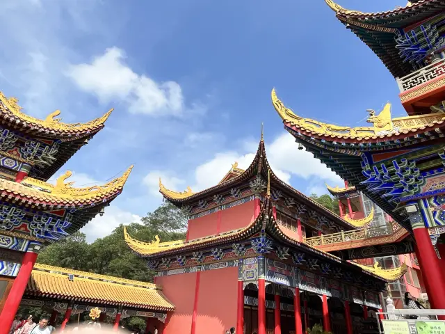 Dongguan Day Tour | Guide to Daling Mountain Elevator Guanyin TempleGuide to Daling Mountain Elevator Guanyin Temple. This is the first time I've seen a temple with an elevator, it's truly a blessing for the lazy. The temple is located deep in Daling Mountain of Dongguan, and it is said to have a history of over three hundred years. It's much larger than Hongfa Temple in Shenzhen, and it's both beautiful and photogenic. ⛩️ About the Temple ⛩️ ① No reservation is required for the temple, but it is recommended to go early as the roads are narrow and can get congested during peak times. ② The temple offers vegetarian meals from 11:00-14:00, priced at 25 per person (including a 5 yuan deposit, which is refunded if you finish your meal). ③ Incense can be purchased at the entrance for 20 yuan per bundle, which is enough for worshipping all the deities. ④ The temple architecture is majestic; it is advised to dress neatly to avoid revealing clothing. ⑤ Photography of the Buddha statues is not allowed! Do not step on the temple threshold X ⑥ Visiting duration: 1-2 hours, there is an elevator available so it won't be too tiring, but if you like taking photos, it might take longer. ⑦ Upon exiting the temple, about 300 meters to the right, there is a square lawn where you can see the full view of the Guanyin Temple, and it's a great spot for taking photos of people and scenery. ⑧ When the visit is almost over, call a taxi in advance to go down the mountain, and there are also private cars available. Transportation: It is recommended to drive there, there is a parking lot P about 300 meters from the temple (there is no direct bus to the entrance of Guanyin Temple, and the park entrance is a few kilometers from Guanyin Temple, those who enjoy hiking can also choose to walk up). Location: Guanyin Temple in Daling Mountain Forest Park Detailed address: Guanyin Temple, Daling Mountain Forest Park, Humen Town, Dongguan Cityclever.deeanna
You Might Also Like
Yinxian Mountain Villa
6.0
4.5/53838 Reviews
-HK$ 4.30
From HK$ 69.86

Xiangshi Zoo
5.3
4.4/52230 Reviews
-HK$ 42.99
From HK$ 85.98

Canton Tower
8.6
4.5/533973 Reviews
From HK$ 161.22

Window of the World
8.5
4.4/526817 Reviews
From HK$ 128.97
Nearby Attractions
Yinxian Mountain Villa | 【 dong guan 】 2024 zhou bai hao 「 ben fu 」 shi jie xun hui yan chang hui | Nanshe Ming and Qing Ancient Village | nan she cun | Xiangshi Zoo | Songshan Lake | Humen Fort | Huawei European Town | dong guan hai zhi yun ji di hai yang gong yuan | Yuehuiyuan | Opium War Museum | Xixi Ancient Village | Sea Battle Museum | Guanyin Temple | Keyuan Museum | Fantasy Baihuazhou | Dongguan Ocean Cubic | Dongguan Botanical Garden | Dongguan Dongcheng the Water Cube Natatorium | Houjie | 【 dong guan 】 guan xin yan 《 yue 》 22 zhou nian xun hui yan chang hui | Xiabafang | Palm Valley Water City | Linze Xuxiao Yanchi Yu Humen Paotai Site | Huayang Lake Ecological Wetland Park | Lemin Water Park | Weiyuan Fort | Songshan Lake Park | Lin Zexu Buring Opium Pool Site | Dongguan Fangao Xingkong Art Museum
Popular Types of Attractions in Dongguan
Parks | City Parks | Children's Play Areas | Water Parks | Architecture & Landmarks | Squares | Featured Neighborhoods | Historical Architectures | Religious Sites | Memorial Temples | Churches and Cathedrals | Temples | Lifestyle | Libraries | Campgrounds | Resorts | Exhibition Centers | Fine Art Galleries | Exhibition Halls | Museums | Nature | Mountains | Beaches | Forests | Fitness | Badminton Courts | Stadiums | Basketball Courts | Historic Sites | Historical Sites
Popular Restaurants in Dongguan
食悅圍城·龍蝦館 | Tai Zhong Dong Hai Restaurant (Guomao Branch) | 塘廈三正半山溫泉飯店·漢宮中餐廳 | 常平竹升雲吞麪·鮮蝦雲吞麪(常平總店) | 和慶食館(總店) | 棠心鮑葡萄酒餐廳 | 小運河·啫啫(33小鎮店) | Ru Xuan·Seafood Casserole porridge· Chaoshan Cuisine | 東莞人家風味酒樓 | Café Viata | 上海老飯店(世紀廣場店) | 慶粥今宵·味道東莞(西平店) | 莞府家宴·東莞菜(市民服務中心店) | 塘廈三正半山酒店(沙利文西餐廳) | 厚街國際大酒店·360度旋轉餐廳 | SHUNFENGSHANZHUANG | 四季大酒樓(厚街厚沙店) | 蜆皇活貝料理·粵菜海鮮(西平店) | 東莞康帝國際酒店·艾斯本自助西餐廳 | Qi Kang Shan Fang | Taizhong·East Ocean Haidu restaurant (Nancheng branch) | 球記飯店(北柵店) | Guan Xiang Lou (Yongtai Branch) | 旺角寶港式茶餐廳(寮步店) | Wangpin Steak | 東莞松山湖凱悦酒店·松山茶居 | 潤澤園椰子雞(匯一城總店) | 橫瀝牛莊(總店) | 永成糖水店 | 勝記燒鵝美食
Popular Destinations
Thiruvananthapuram Travel | Florence Travel | South Korea Travel | Quanzhou Travel | Penang Travel | Indonesia Travel | Vietnam Travel | United States Travel | Fujikawaguchiko Travel | San Francisco Travel | Switzerland Travel | Guangdong Travel | Guangxi Travel | Singapore Travel | Tianjin Travel | Namibia Travel | Chandigarh Travel | Bovec Travel | Koper Travel | San Sebastian Travel | Sighisoara Travel | Haute-Corse Travel | Becket Travel | Getaria Travel | Delemont Travel | Anning Travel | Stone Town Travel | Abbeville County Travel | Kingston upon Thames Travel | La Grande Travel
Recommended Attractions at Popular Destinations
Bangkok attraction near me | Manila attraction near me | Tokyo attraction near me | Taipei attraction near me | Hong Kong attraction near me | Seoul attraction near me | Los Angeles attraction near me | Kuala Lumpur attraction near me | Shanghai attraction near me | New York attraction near me | Shenzhen attraction near me | Osaka attraction near me | London attraction near me | Singapore attraction near me | Guangzhou attraction near me | San Francisco attraction near me | Beijing attraction near me | Macau attraction near me | Bali attraction near me | Paris attraction near me | Jakarta attraction near me | Ho Chi Minh City attraction near me | Orlando attraction near me | Phuket attraction near me | Toronto attraction near me | Chicago attraction near me | Cebu attraction near me | Seattle attraction near me | Istanbul attraction near me | Fukuoka attraction near me
Popular Ranked Lists
Top 3 Luxury Hotels in Yangshuo | Top 29 Local Restaurants in Shanghai | Popular Luxury Hotels Near Phuong Thien | Top 21 Local Restaurants in Vienna | Top 20 Local Restaurants in New York | Popular Luxury Hotels Near Pampatar | Popular Family-friendly Attractions Near Shuangfeng | Top 28 Local Restaurants in Beijing | Top 20 Local Restaurants in Cairo | Popular Luxury Hotels Near Canelli | Top 16 Local Restaurants in Amsterdam | Popular Family-friendly Attractions Near Lingqiu | Popular Family-friendly Attractions Near Mengla | Top 6 Bars in Chun'an | Top 25 Local Restaurants in Foshan | Popular Luxury Hotels Near Nanxiong | Top 16 Local Restaurants in Weihai | Popular Family-friendly Attractions Near Sinan | Popular Luxury Hotels Near Valparaiso | Popular Premium Hotels Near Motheo | Popular Luxury Hotels Near Richmond | Popular Luxury Hotels Near Canyon Point | Top 20 Local Restaurants in Chicago | Top 4 Bars in Linyi | Popular Luxury Hotels Near Madrid | Popular Luxury Hotels Near Padalarang | Top 18 Local Restaurants in Bali | Popular Family-friendly Attractions Near Xinyi | Top 22 Local Restaurants in Yangzhou
Popular Trip Moments
Dongcheng Wanda Store·Sui Xin Hotel | Dongguan Tanxiang Island, a paradise on earth | Supper Secrets 🤫 Freshly Cut-Pig Congee unveiled! 🐽 | Dongguan Botanical Garden | Huawei Songshan Lake In Huawei European Town 🇨🇳 | Dongguan Exhibition Viewing Guide!! Indoor niche and free!! | Visit the Miyazaki Hayao Comic Park in Dongguan | Dongguan Guanyin Mountain One-Day Tour Guide!! | Dongguan|Chang'an Park|A great place for walking with kids|Let's go fishing and feed the fish together | Yinping Mountain in Dongguan: A spectacular sea of clouds and sunset at an altitude of 800 meters | Checked in at Dongguan Sanzheng Banshan Hotel | Enjoy the room rate of Huashou Travel as if at home, and stay at the quality of Hyatt Hotel! | Dongguan Weekend Travel Choices | Dongguan Botanical Garden is in full bloom | Daling Mountain guanyin Temple 🛕 🇨🇳 | Visited Shongshan Lake Dongguan 🇨🇳 | Dongguan Xixi Ancient Village Travel Guide | Huawei European Town 😍 Dongguan China 🇨🇳 | Dongguan! I stayed in a very nice hotel in Dongcheng | Checked in at Dongguan Songshan Lake | Shuilian Mountain, one of the six major forest parks in Dongguan | You must come and experience the irresistible itch of nature | #Michelin Restaurant #MUST try in Dongguan #Great Sichuan Restaurant | Dongguan, Yinping Mountain. | Dongguan Welcome Hotel | Get close to nature, absorb moisture, Dongguan Botanical Garden | Don't come and play until you don't want to leave | Dalingshan, Dongguan | Dongguan's Huawei European Town is truly dreamy | Weekend Leisure Trip | Cycling around Songshan Lake
Popular Travel Types
More Things To Do in Dongguan
Shenzhen/Hong Kong/Macau Guangdong-Hong Kong cross-border through-car chartered car for fast customs clearance with Chinese-speaking driver 24-hour airport Hotel Airport Transfers at Huanggang/Shenzhen Bay Port | Pearl River Estuary Opium War Naval Ancient Fort Private Tour | China eSIM Day Pass/data Package days selected without cards QR code | China Mainland eSIM|China Mobile Unlimited 4G High Speed Data | China·Hong Kong·Macau eSIM|Unlimited 4G High Speed Data | [China Mainland] eSIM | SIM to China | 8GB 8days 4G high speed | Global (66 Countries) eSIM Data Package (QR Code) | Asia・Australia eSIM|AIS SIM2Fly 8 days 6GB High-speed Unlimited 5G/4G Data | Mainland China eSIM |China Mobile 4G high-speed unlimited data eSIM | Mainland China + Hong Kong + Macau eSIM 4G Data Daily Plan QR Code | China Mainland + Macau 5G/4G eSIM QR Code by China Unicom | [China, Hong Kong and Macau] 4G network | Unlimited traffic | Self-pickup at the airport | WiFi rental, high-speed traffic, shared by multiple people, ready to use at startup, 12H standby, 24H customer service | eSIM for China, Hong Kong and Macau. Universal for Mainland China/Hong Kong/Macau. Optional days for travel and business. QR code | Mainland China + Hong Kong + Macau eSIM Data Plan QR Code | China/Hong Kong/Macau eSIM 4G high-speed network QR code | Private Day Tour to Chimelong Paradise and Birds Park from Guangzhou | 6-Day Private Tour from Guangzhou to Guilin | Private Guangzhou Lay Over Tour with 9 Options | Private Guangzhou City Sightseeing Tour Including Lunch | Private Day Tour from Guangzhou to Shenzhen | Shenzhen Private Guided 1-Day Tour Happy Harbor Sea World Greater Bay Area No. 1 (Hong Kong-Zhuhai-Macao Bridge Route) | Global eSim for 140+ countries (sent via email) by Xplori | Guangzhou Private Day Tour of Xiqiao Mountain, Wong Fei Hung Lion Dance Martial Arts Museum and More | Out of Beaten Track and Hidden Gems Private Guangzhou City Tour | AIS Global eSIM data package (QR code) | Foshan Jianjia Cangcang Field Camp·Overnight Camping [Space Capsule Private Bathroom·Corporate Team Building·Parent-Child Activities·Friends Reunion·Festivals] | Guangzhou PM Private Tour: Canton Tower, Buffet Dinner, Cruise | 4-Hour Private Tour to Museum of Nanyue King & Academy of Clan Chen in Guangzhou | Guangzhou Private Day Tour of Baiyun Mountain, Dr. Sun Yat-sen's Memorial Hall, Liurong Temple | Yum Cha Dim Sum Dinner and Pearl River Night Cruise Private Tour
Payment Methods
Our Partners
Copyright © 2024 Trip.com Travel Singapore Pte. Ltd. All rights reserved
Site Operator: Trip.com Travel Singapore Pte. Ltd.
Hong Kong Travel Agency License (No. 352367) held by Ctrip.com (Hong Kong) Limited.
Site Operator: Trip.com Travel Singapore Pte. Ltd.
Hong Kong Travel Agency License (No. 352367) held by Ctrip.com (Hong Kong) Limited.
Dalingshan Forest Park is located in Dongguan City, surrounded by Daling Mountain, Humen, Dalang and other towns, 530 meters above sea level, there is a pavilion on the top of the mountain, because the tea trees are all over, the famous tea fun.
Dalingshan Forest Park is a great place to hike and campsite. A walk into nature's park, one can encounter many interesting sights - the lush, green trees, waterfalls, rivers, temple, big spider - along the way. However, during rainfall, it can be muddy, slippery and dangerous; so one needs to be careful when hiking in the forest.
Dalingshan Forest Park is located in the southwest of Dongguan City, Guangdong Province, the northeast of the Pearl River Estuary, north to Hou Road, east to the Daling Mountain Mountain as the boundary, southeast to the southeast of Lotus Mountain as the boundary, southwest to Daling Mountain Forest Farm Department, northwest to Houjie Daqi Village, It spans four towns (Houjie Town, Humen Town, Chang'an Town, Dalingshan Town, Daling Mountain Forest Farm), covering an area of about 74 square kilometers, and has been built in Humen, Houjie, Daling Mountain, Chang'an 4 entrance squares, 78 kilometers of park roads, 31 kilometers of mountaineering trails, and a batch of convenient service facilities. The park is a comprehensive forest park with forest resources as the main body, protecting natural ecology as the main function, and featuring "natural", "quaint" and "wild fun". It can be used for sightseeing, scientific examination, leisure and wellness and fitness. The park is a low mountain and hilly landform. The mountains in the park are undulating, the peaks are stacked, and the mountains are deep. The highest point is "Tea Peak" at an altitude of 530.1 meters. On the top of the peak, you can enjoy the new appearance of the city and the surrounding lakes and mountains. In the park's alpine forest, there are many strange images of mountain stones, such as flagstone, meteorite, lotus stone, lover stone, its shape is thousands of shapes, like people, like animals, like things, lifelike. These stones are distributed throughout the park, dotted with their quiet beauty, and highlight the nature and wild fun of the park.
Dalingshan Forest Park spans Daling Mountain, Houjie, Humen, Chang'an four towns, covering an area of 74 square kilometers, with waterfalls, streams, tea mountain trails, step tea gardens, original trails, suitable for hiking and parent-child travel.
There are many forest parks in Dongguan. The first time I went to Dalingshan Forest Park, the altitude was 530 meters. You can drive to the Guanyin Temple area, so that one-third of the way is saved. Follow the road straight all the way, until the last 200 meters are replaced by stone steps. The mountaintop is named after the tea mountaintop because of its wide variety of tea trees.
大岭山森林公园位于东莞横跨厚街镇、虎门镇、长安镇、大岭山镇、大岭山林场,有虎门、厚街、大岭山、长安4个入口,是以自然森林资源为主的好景点,最高点“茶山顶”海拔530.1米,登上峰顶,可欣赏城市新貌,也可欣赏周边湖光山色。在公园的高山密林中,还有许多形象奇特的山石分布在公园各处,等你走走看看去发掘咧!整体而言是一个非常非常好的休闲踏青的地方!