【最新】本月優惠代碼組合
概要預訂附近評價贏取獎品推介
分享至
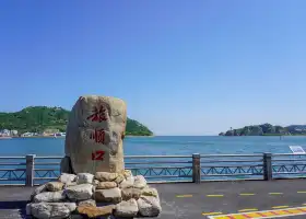
老鐵山黃渤海分界線
The Huang-Bohai Seas Demarcation Line in Laotie Mountain4.9
85條評價
 根據7個評價
今日營業時間已過 明日8:00-17:30開始營業
建議逗留時間:1小時
地址:
遼寧省大連市旅順口區老鐵山燈塔下方地圖
電話:0411-86218828
其他遊客感想:
梅姐窮游中國行第46天,下午大連旅順黃渤海分界線風景區在遼東半島的最南端,有一座老鐵山,素有“一山擔雙海”之譽。進入景區后,順着道路走到山的盡頭,能清晰的看到黃渤海自然分界線。其中渤海的海水偏黃偏混濁,黃海的海水偏藍偏清澈,和我們在山東煙台蓬萊閣看到的黃渤海分界線是相同的,不過左右位置不同而已。老鐵山也是遼東半島的最南端,今天背光沒法把黃渤海自然分界線的碑照下來。在2000年8月8日早上八點,現北京體育大學副校長張健,從老鐵山黃渤海自然分界線位置(老鐵山岬)下海,不藉助任何漂浮物橫渡海峽,總用時50小時22分,總行程123.58公里,從蓬萊閣東沙灘登陸,創造了橫渡海峽最長的世界紀錄,至今未被打破。
更多9人讚好
老鐵山黃渤海分界線的景點亮點
部份資訊可能由 Google 翻譯處理
老鐵山黃渤海分界線位於大連旅順口區,這裡是絕佳的觀海之地,站在這里遠眺,可看到黃海與渤海的海水分界線,東部黃海裡的水是深藍色,而西部渤海內的水卻顯得渾濁,是微黃色,融合在一起的大海,卻有不同的顏色,看起來真的很神奇。
老鐵山黃渤海分界線的附近推薦
老鐵山黃渤海分界線的評價
部分評論可能已透過 Google Translate 翻譯撰寫評價
 (85條評價)Trip.com
 (7條評價)TripAdvisor
/5
完美條評價全部 (85)
最新
附圖 (52)
已驗證訂購 (1)
好評 (63)
負評 (3)
- 1
- 2
- 3
- 4
- 17
更多推介
軍港遊園
6.6
4/5417條評價
HK$32.43 起
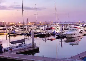
東港遊艇碼頭
5.1
4.6/544條評價

大連聖亞海洋世界
7.4
4.4/515648條評價
節省 HK$5.40
HK$254.03 起
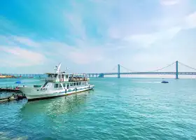
天祥號觀光遊輪
4.6
4.6/5111條評價
節省 HK$37.84
HK$135.12 起
附近景點
大連熱門景點類型
大連熱門餐廳
正黃旗海鮮燒烤大排檔(延安路店) | 杉木日本料理·Salmon&Tuna | 喜鼎海膽水餃(東港店) | 錢庫裏海鮮自助(星海店) | 大連君悦酒店·樂廚 | 九福自慢料理(天津街店) | 趙記老鋪滿族王府酒樓(星海店) | 紫航海鮮大飯店 | 辻鮨割烹日本料理 | 萬寶海鮮舫(勞動公園店) | 海味當家·蒸鍋海鮮(民主廣場創始店) | 品海樓(老虎灘店) | 旅大印象餐廳(黑石礁店) | 南山小漁村(七七街店) | 牛道·和牛九食 | 銀杏西餐WINE BAR CELLAR | 奕景酒家(星海廣場店) | 天順漁港·海景餐廳(星海廣場店) | 日豐園·海腸水餃 大連一絕(小平島總店) | 蘇大嘴·海鮮燒烤鴿子王(中山廣場店) | 常鮮樓常來嚐鮮海膽館 | 千日賀茶餐廳(羅斯福店) | 馬路邊上·小海鮮燒烤(八一路店) | 金碧輝煌社區燒烤專營店(明澤街店) | 日月昇漁家菜(五一廣場店) | 漁家味道(青石路店) | 欣欣餐廳·大連老菜(中山區解放路武昌街店) | 大連君悅酒店·香匯餐廳 | 吾隆香·海鮮老菜·鍋貼(錦綉店) | 松雲居
熱門目的地
熱門目的地的推薦景點
深圳的附近景點 | 台北的附近景點 | 東京的附近景點 | 香港的附近景點 | 大阪的附近景點 | 曼谷的附近景點 | 澳門的附近景點 | 首爾的附近景點 | 廣州的附近景點 | 珠海的附近景點 | 上海的附近景點 | 倫敦的附近景點 | 福岡的附近景點 | 吉隆坡的附近景點 | 高雄的附近景點 | 新加坡的附近景點 | 北京的附近景點 | 沖繩的附近景點 | 巴黎的附近景點 | 名古屋的附近景點 | 札幌的附近景點 | 台中的附近景點 | 成都的附近景點 | 布吉的附近景點 | 京都的附近景點 | 悉尼的附近景點 | 馬尼拉的附近景點 | 溫哥華的附近景點 | 佛山的附近景點 | 釜山的附近景點
熱門排行榜
大連7大高級餐廳 | 布拉格5大酒吧 | 威尼斯15大高級餐廳 | 上思附近的熱門親子景點 | Comarca de la Sidra附近的熱門奢華酒店 | 丁沃爾的熱門豪華酒店 | 德江附近的熱門親子景點 | 釜山5大高級餐廳 | 羅特附近的熱門奢華酒店 | 漢川附近的熱門親子景點 | Gorod Voronezh的熱門豪華酒店 | 奧倫堡的熱門豪華酒店 | 浪卡子附近的熱門親子景點 | 貴陽5大高級餐廳 | 赤峰附近的熱門親子景點 | 聖彼得港附近的熱門奢華酒店 | 綏化附近的熱門親子景點 | 重慶15大高級餐廳 | 尼沙瓦州的熱門豪華酒店 | 杭州的熱門高級餐廳 | 東京19大夜間景點 | 曼谷10大夜間景點 | 首爾11大夜間景點 | 澳門12大夜間景點 | 多倫多的熱門夜間景點 | 三藩市的熱門夜間景點 | 羅馬的熱門夜間景點 | 峇里島的熱門夜間景點 | 布吉的熱門夜間景點 | 清邁的熱門夜間景點
熱門 Trip Moments
神秘東方菩提界·主題公園 | 大連|海之韻 | 大連市內這條通往大海的路可太好拍啦 | 大連|黑石礁 | 這個季節的大連簡直就是人間理想 | 莊河 歇馬山莊 | 大連周邊我的私藏溫泉小院,天暖了帶娃泡湯 | 旅遊攻略,要做就做最詳細的(大連) | 接下來大連的春天是這樣的| | 黃渤海分界線 | 大連這家酒店的性價比太高了驚呆了 | 大連老牌高星酒店:開業至今近30年,卻依舊是全市招牌酒店! | 又又又來了開往春天的公交車站 | 4月大連超全旅遊攻略省錢暢玩不踩雷 | 這是只有漫畫才有的景色啊,大連菱角灣老虎灘絕美 | 新頂奢,東北首家四季酒店於大連揭幕! | 人生建議:逛完他家再離開大連 | 探索大連森林動物園,開啟動物王國之旅! | 大連賞櫻全攻略~嘤嘤嘤~櫻櫻櫻 | 大連晨曦沙灘/怪坡/海底大峽谷合集 | 大連禧合酒店性價比不要太高!!! | 計劃前往東三省的大連旅行 | 大連的商場真的不能隨便進!很難空腹出來 | 我在大連找到了顏值超高的拍照打卡地漁人碼頭 | 大連的春天已經開始了… | 大連極具性價比的海景民宿 | 這裡是中國的天鵝城堡不在國外就在大連!!! | 大連威尼斯水城 | 大連新春打卡聖地!粉色遊龍! | 大連|星海廣場極致的浪漫—跨海大橋燈光秀
更多大連好去處
eSender- 中國內地 eSIM 日用包/ 流量套餐、天數可選 無需取卡 QR code | 大連港東五街+望魚山+東港音樂噴泉廣場+香爐礁碼頭+夏家河子海濱公園一日遊【包車旅拍,攝影師帶隊,送五張照片】 | 軍港遊園+旅順潛艇博物館+闖關東影視基地一日遊【旅順專線/金牌講解/景點入內參觀/不外觀/不擦邊】 | <私人包機>邊陲小鎮! 【大連出發】丹東斷橋、鴨綠江遊船、虎山長城、一步跨一日遊<飯店接送/日文導覽/含午餐/大連出發> | 歷史名城瀋陽一日遊〈大連出發〉搭乘高鐵,遊覽瀋陽故宮、北陵宮、張氏師父、滿洲事變歷史館等<瀋陽站接送/日文導遊/含午餐/出發從大連出發〉 | <私人包車>大連旅順半日觀光-日俄戰爭激戰遺址! 203高地、東雞關山、白玉山、旅順站<飯店或機場接送/日文導覽/1人出發> | <包車>大連旅順1日遊東雞冠山、203高地、旅順車站、水營、中山廣場、大和旅館、滿鐵總部、日本小鎮等含午餐<酒店接送/日語導遊/1人出發 > | <私人憲章> 日俄戰爭的激戰遺址!大連旅順203高地、東雞關山、旅順車站、水營、旅順博物館、白玉山塔等一日遊,含午餐<飯店接送/日文導遊/1人出發> | 遼寧大連星匯水上運動中心/尾波沖浪包船體驗【全新進口造浪艇+全程教練指導+零基礎解鎖沖浪】 | 遼寧大連伍浪尾波沖浪包船體驗【進口造浪艇+全程教練指導+零基礎解鎖沖浪】 | 大連星鹿緣小鎮·不過夜露營【星空屋/小木屋+4-6人燒烤套餐】 | 遼寧大連尾波沖浪體驗【進口豪華造浪艇+專業教練教學+零基礎可體驗】 | 大連金石灘度假區+金石灘喂海鷗海上垂釣+十里黃金海岸一日遊【地質公園/金石萬巷/金石園/蠟像館/華夏文化博物】 | 大連金石灘度假區+金石灘喂海鷗海上垂釣+十里黃金海岸一日遊【1-6人團·趕海抓螃蟹·地質公園·木船撈海帶】 | 大連私人導覽1日遊 旅順口景區 | 大連銘湖國際温泉滑雪度假區+銘湖國際牧場+熊洞街一日遊【浪漫大連行/行程可調/專車出行】 | 大連出發-新疆烏魯木齊、吐魯番、敦煌絲路六日遊 | 金石灘度假區+金石蠟像館+大連魯能海洋温泉一日遊【浪漫大連行/行程可調/專車出行】 | 東方威尼斯水城+漁人碼頭+濱海路西段木棧道+大連森林動物園一日遊【大連海景遊/行程可調/專車出行】 | 大連私人導覽1日遊 棒棰島 老虎灘海洋公園 東方威尼斯水城 | 大連私人導覽1日遊 東方威尼斯水城 東港遊艇碼頭 棒棰島 | 大連港東五街+老碼頭帆船基地+海之韻公園+東方威尼斯水城半日遊【下午出海夜場,包車旅拍,攝影師帶隊送五張照片】 | 【大連出發】古都西安2晚3天之旅 | 【大連出發】熱門城市重慶、世界遺產大足石窟3天2夜之旅 | 大連星海廣場+星海灣大橋最佳觀景點+銀沙灘浴場+菱角灣+晨曦沙灘一日遊【包車旅拍,攝影師帶隊,送五張照片】 | 中國大連+星海廣場+大連老街+東方威尼斯水城+大連聖亞海洋世界一日遊【大連家庭親子一日遊|1單1團+可定製】 | 跨海大橋+三寰牧場+星海廣場+大連貝殼博物館一日遊【浪漫大連行/行程可調/專車出行】 | 大連遊艇俱樂部帆船出海半小時(喂海鷗、眺望港東五街)多碼頭可用 | 大連私人導覽1日遊 老碼頭 棒棰島 星海廣場 濱海路 | 中國闖關東影視基地+日俄監獄舊址博物館+白玉山景區+旅順潛艇博物館+泊霞灣公園一日遊【追憶歷史,行走旅順】
梅姐窮游中國行第46天,下午大連旅順黃渤海分界線風景區在遼東半島的最南端,有一座老鐵山,素有“一山擔雙海”之譽。進入景區后,順着道路走到山的盡頭,能清晰的看到黃渤海自然分界線。其中渤海的海水偏黃偏混濁,黃海的海水偏藍偏清澈,和我們在山東煙台蓬萊閣看到的黃渤海分界線是相同的,不過左右位置不同而已。老鐵山也是遼東半島的最南端,今天背光沒法把黃渤海自然分界線的碑照下來。在2000年8月8日早上八點,現北京體育大學副校長張健,從老鐵山黃渤海自然分界線位置(老鐵山岬)下海,不藉助任何漂浮物橫渡海峽,總用時50小時22分,總行程123.58公里,從蓬萊閣東沙灘登陸,創造了橫渡海峽最長的世界紀錄,至今未被打破。
老鐵山角,位於遼東半島的尖端,延伸黃海和渤海之中,形成黃海和渤海的自然分界,在海水的顏色上可謂“涇渭分明”。東部黃海部分水是深藍色,而西部渤海水卻顯得渾濁,略呈微黃色。
海水的確有黃有深藍,相互交錯的樣子,不是直直的分界線。地理位置值得一去,地圖上雞頭肉垂的位置,遼東半島的天涯海角呀。
現在去看得不是很明顯
大連旅順老鐵山的黃渤海分界線,清楚看到黃渤海的不同
The dividing line between the Yellow Sea and the Bohai Sea, natural scenery. The sea that merges together has different colors. It looks really amazing. It's worth visiting personally. I'm telling you the route. The boundary between Huanghai and Bohai Sea belongs to Lushun District. I live in Dalian Railway Station. I think the traffic is very convenient. Go to North Plaza of the Railway Station and there is a pavilion opposite the vegetable market of Dalian Light Rail Station. Just go there to buy tickets and go to Lushun South. About an hour and a half to Lushun bus station, after getting off, take No. 18 or No. 19 to Laotieshan Hub Station in situ, then wait for No. 216 to get off at Chen Jiacun (No. 216 is on the top of the map, there are not many cars, you can grasp the time). After getting off, you can see the sign to the Huanghai-Bohai Sea demarcation line, which is about 10 minutes'walk. Finally, when you get to Lushun, you can arrange the route. There are many things worth visiting, so you can learn about the humanities and history.
算好了天氣來的,就為了看黃渤海分界線,地方很遠,司機很棒,不催促我們,看見了東北的海角天涯,大海很壯觀。值得推薦的線路